

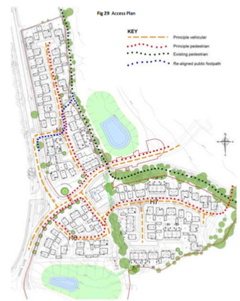
Vehicle roads

The detailed planning application (“reserved matters”) for the first phase of the West of Stonehouse development has been filed at SDC By the builders ‘Redrow’.
It is worth a look, as there are lots of detailed diagrams of the proposed layout, access roads etc.
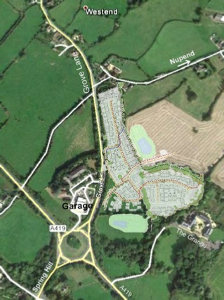
The above diagrams give a flavour. This application is for 103 units including 15 ‘social’ rent and 16 ‘affordable’ rent units. They are virtually all 2-storey buildings (with single story garages in front), with just the two dwellings at the very top centre of the diagram being described as 2.5 stories.
The threatened vehicular access onto Nupend lane has been removed, as mentioned previously.
The SDC Local Plan (p58) describes the overall development as ‘an urban extension to Stonehouse’. There is no mention in the application for this phase of any improved access to Stonehouse, nor any new ‘facilities’. The Design and Access document remarks that the new houses are within walking/cycling distance of Churchend (…and therefore our school….).
Completely missing is the agreed ‘structural landscape buffer’ between this part of the development and the existing Westend houses at the junction of Grove Lane and Nupend Lane. The Stroud Local Plan and our Neighbourhood Development Plan require structural landscape buffers to protect the distinct identity of each of the hamlets. This was specifically added to the Approved Revised Area Masterplan in December 2016.
To see the application plans in detail, and/or make comments go to
www.stroud.gov.uk/apps/planning and search for application ref S.17/0095/REM
or click here


Eastington Community News Magazine. Community news for and by the people of Eastington, Gloucestershire
| Parish Council News |
| District council News |
| County Council News |
| Council links |
| Village Agent |
| Nbhd Warden |
| West of Stonehouse (WoS) |
| Ecotricity |
| Eastington Primary School |
| Playgroup |
| For the Little Ones |
| St Michaels Anglican Church |
| Eastington Methodist Church |
| ECLT (Land Trust) |
| EARS (Road Safety) |
| ECO (Orchard Group) |
| PROWD & Walking Group |
| Slimming World |
| Mr Beebee |
| Canal Update |
| Dog Bins |
| Pond Restoration |
| Weather |
| Cheese making |
| Defibrillators Installed |
| Phone Box |
| Severn Vale Rotary |
| Eastington Egg Hunt |
| Other Eastington Events |
| Activities nearby |