Tithe Maps and Field Names
Many people will be familiar with the term ‘tithe’ – it often crops up in the name of houses, farms and roads.
The name originates from the long-
Gradually, the tradition of providing goods and livestock began to dwindle, and from the 17th century it became increasingly common for farmers and landowners to instead pay an agreed sum in cash. This arrangement carried on into the first quarter of the 19th century although there were often complaints about unfairness and inequalities. However, in 1836, the ‘Tithe Commutation Act’ brought a degree of stability to the system. From now on, all payments were made in cash.
Of course, that wasn’t the end of the matter. To come up with the appropriate cash payment, it was now increasingly important to assess who owned what land and property, its value, and what it was used for. This enabled the authorities to determine how much each landowner was obliged to pay. As part of this process, tithe maps were compiled for each parish, including Eastington. Our tithe map was compiled in 1839 by Charles Baker, surveyor of Painswick.
As each was essentially a unique undertaking, tithe maps can be a bit variable in their quality and accuracy. However, they usually cover an entire parish and show individual fields or plots of land (arable, pasture or meadow), woods, rivers and other bodies of water, houses, cottages, barns, other buildings, yards, gardens and workshops. Each is numbered for reference.
Some maps even included the names of individual fields, which brings us to the present topic. Eastington’s tithe map is a fine example of this, as every strip of land, even insubstantial pockets, had a name. And what names they were! So in the parish we have such evocative place names as Heron Grove, Great Hill, Mangerstone, Wobow, Aspla, Hither Pie, Great Hurns, Tumpey Ground, and Great Oldbury. To the south of the village lay the wonderfully named Upper and Lower Honey Hills, to name just a few.
What was surprising was just how many orchards there were. Today, most have been grubbed up or built over, but a century or so ago, they formed important sources of food for many villagers. For example, there was Flax orchard, Westend orchard, Hitchings Croft orchard, Sparrow Croft orchard, and Court orchard. There were many others differing widely in size. There was also Conygre orchard, a name recently revived for the community orchard adjacent to the churchyard. Conygre is an indication that this was once the location of a walled warren, where rabbits (‘conies’) were raised as a delicacy for the local gentry.
Some field names on the tithe map hint at how they may have been used at some point in history. So upstream from Millend Mill is a field once known as Rack Leaze, an indication that this was where woollen cloth manufactured at the mill was stretched out on tenter racks to dry. Across the river is a large field called Floodgate Furlongs (the one where we all go sledging in the Winter!). The lower part next to the river originally hosted withy (willow) beds, once so important for basket weaving. Floodgates probably refers to the gates once used to control water supplied to Millend’s water wheels but may also be connected with water control to the withy beds.
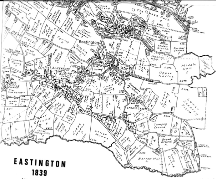
Elsewhere in the village were fields called Brick Close (at Nastend) and a plot known as Hither Pugpits. A pug mill was a machine used to process clay dug from pits for brick making, so perhaps both refer to the making of bricks in those locations. In earlier days, clay bricks were simply fired in stacked heaps known as clamps, so would leave little trace once finished with. Perhaps these names are a distant echo of this once-
Other field names reflected past or present land owners. So we have fields such as Sauls Patch, Brains Ground, Madam Smalls meadow, Warners Tything, Abigails Mead and Buddings Ground. A few local road names give a nod to some of these old names – for example, Middle Croft (built on the field of the same name) and Budding Road.
The map also lists some more intriguing names. For example, there was Green Cheese Leaze and Captains Meadow. There was also the interestingly named Thieves Green. All must have once had a story to tell, probably harking back to some long forgotten incident.
Today, few of these wonderful old names are used. In fact, the vast majority have been forgotten. Only a few generations ago, many villagers were intimately tied to agriculture as farmers or farm workers. Such was its importance to the general wellbeing of the village that even those that earned their living in some other way, such as the local cloth mills, took an interest in the subject. Today, few people are directly involved in local agriculture and most of these old names have drifted off into the mists of time. It seems a sad loss.
Stephen Mills.